IIRS Outreach Programme
With the advent of Information and Communication Technology and improved broadband internet connectivity has enhanced the scope of learning any time anywhere, going beyond the traditional classroom approach. To support distance learning, Indian Space Research Organisation, Government of India has launched dedicated communication satellite called EDUSAT in 2004. The satellite is widely used for variety of applications like Tele-education, Tele-medicine, Village Resource Centres, mobile satellite services, disaster management support and television broadcasting educating farmers for agriculture and other purposes. One of the prime applications of EDUSAT satellite is tele-education at various levels (i.e. school level/UG/PGlevel) by different ministries/autonomous organizations/ departments/institutions/universities in India effectively utilizing the EDUSAT for Tele-education.
The initial focus of IIRS was to use EDUSAT/INSAT 4CR satellite for distance learning but extended the scope to use internet so that access to large number of institutions/universities /individuals with little cost to the User. Today this programme is linking more professional and user departments and ministries in the country to develop their skills in geospatial technologies and its applications. The IIRS outreach programme is being conducted through following two major modes:
- Live and Interactive classroom sessions (also known as EDUSAT)
- E-learning based online courses
The live and interactive mode of distance learning is through Internet and A-view software platform developed by Amrita e-learning Lab in collaboration with Ministry of Human Resource Development (MHRD) Government of India. The live classroom sessions are being conducted during 4:00 PM to 5:30 PM on daily basis through state of art studio facility setup in the Institute.
IIRS has set up a state-of-art studio facility and control room to broadcast live and interactive classroom sessions and practical demonstrations through its Distance Learning Center. The high definition video quality is used to broadcast to its user for better quality transmission.
Further to enhance the outreach of geo-spatial science and technology, IIRS has developed e-learning contents and Learning Management Systems (LMS) for different certificate courses in Remote Sensing and geo-spatial technology (http://elearning.iirs.gov.in). The e-learning courses are self-paced and learner centric courses. The syllabus of the courses is as per latest developments and trends in geo-spatial science and technologies with specific focus on Indian case studies for geo-spatial applications. The learning is made available through interactive 2D and 3D animations, audio, video for practical demonstrations, software operations with free data applications. The learning methods are implemented to make it more interactive and learner centric application with practical examples of real world problems.
Student Registration Form Link
IIRS Completed Program List
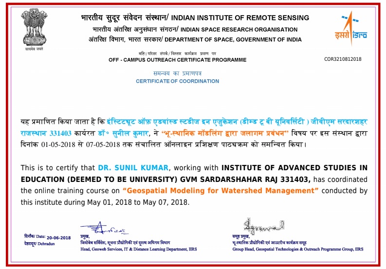
Program Coordinator
Dr. Sunil Kumar
HoD Department of Geography
IASE Deemed to be University
Sardarshahr Churu Rajasthan
PIN 331403
Mob – 8505003520
sunilsairamup@gmail.com